October 1, 2026



The Atlantic hurricane season runs from June 1 through Nov. 30 each year. For millions of Americans living in coastal and inland communities across the Gulf Coast, the Southeast, and the Atlantic Seaboard, that period is associated with documented and measurable risks. In this report, Mokaram Injury Lawyers, a Houston-based personal injury law firm, examines federal data identifying the cities with the greatest exposure to storm surge, hurricane-force winds, and flooding, drawing on the expanded record of storm impacts from recent seasons.
The National Centers for Environmental Information (NCEI) has tracked U.S. billion-dollar weather and climate disasters since 1980. Of the 403 separate events on that record through Dec. 31, 2024, tropical cyclones have caused the most total damage, totaling over $1.5 trillion, with an average cost of $23 billion per event. Hurricanes are also responsible for the highest number of deaths among all tracked disaster types, accounting for 7,211 fatalities since 1980, according to the National Oceanic and Atmospheric Administration’s (NOAA) hurricane costs data.
By state, the cumulative picture is concentrated in the Gulf and Southeast:
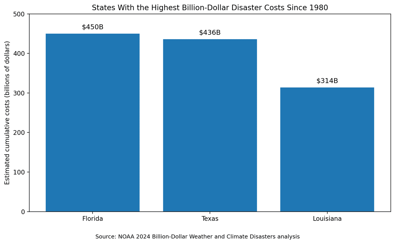
Those figures come from NOAA's 2024 billion-dollar disaster analysis, which also reported that the U.S. experienced 27 separate billion-dollar weather and climate disasters in 2024 alone, totaling $182.7 billion in damages, the fourth-highest annual total on record.
Storm surge, the abnormal rise in seawater pushed inland by a hurricane's winds, is identified by the National Hurricane Center (NHC) as the leading cause of hurricane-related deaths in the United States. The NHC uses its SLOSH (Sea, Lake, and Overland Surges from Hurricanes) model to simulate storm surge risk across the Gulf and Atlantic coasts under Category 1 through 5 scenarios. The agency updated its national storm surge risk maps in 2025, reprocessing Gulf and East Coast data to improve spatial resolution.
The NHC notes that storm surge is not limited to beachfront communities, with risk extending several miles inland in some areas.
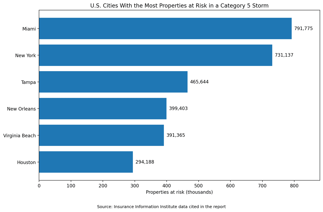
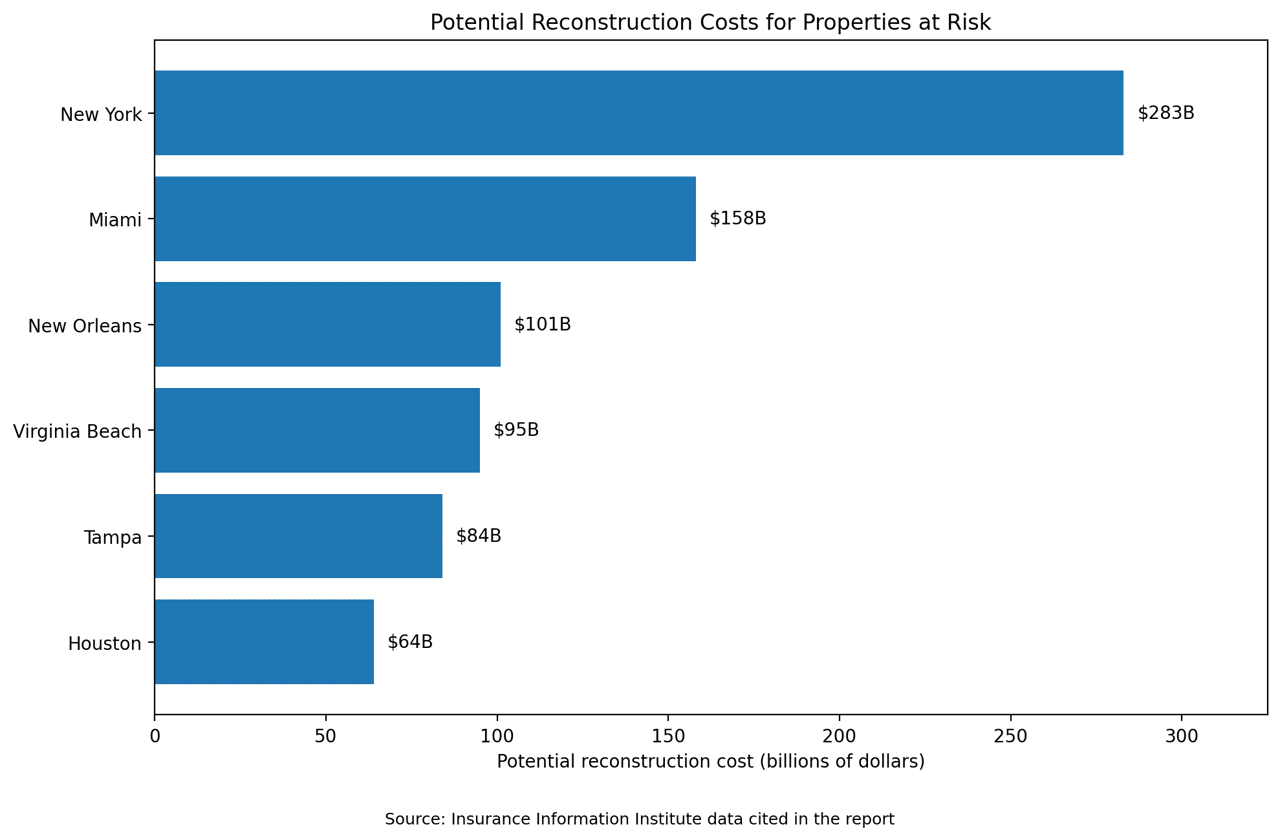
Among the metropolitan areas with the largest number of homes at risk from storm surge and hurricane winds, based on Cotality 2026 risk assessments, include:
Florida has the largest total number of homes with moderate or greater risk of hurricane wind damage at 8,178,843, with a reconstruction cost value of $2.32 trillion. The state also leads in storm surge exposure, with 2,414,132 homes at moderate or greater surge risk, according to 2025 risk data.
Beyond property exposure, historical storm tracking data provides insight into how frequently specific locations are affected. Based on NOAA hurricane research data analyzed by AccuWeather, using 126 years of hurricane track data:
Cape Hatteras, North Carolina, holds the record for the most hurricane and tropical storm contacts since 1871 in tracking data maintained by HurricaneCity.com, which draws on NHC historical archives.
NOAA's 2025 Atlantic hurricane season outlook, released ahead of the June 1 season start, forecasts a 60% chance of an above-normal season. Forecasters projected 13 to 19 named storms, with six to 10 becoming hurricanes and three to five reaching major hurricane strength (Category 3 or higher). NOAA cited continued El Niño/Southern Oscillation (ENSO)-neutral conditions, warmer-than-average ocean temperatures, weak wind shear, and elevated activity from the West African monsoon as contributing factors.
The agency also noted that sea level rise is associated with increased storm surge impact from hurricanes, a trend documented in NOAA's Fifth National Climate Assessment.
This story was produced by Mokaram Injury Lawyers and reviewed and distributed by Stacker.


