


Seekonk Land Conservation Trust News
Branching out— The Great Outdoors
Are you looking for places to walk with your family and/or friends? Are you hoping to spend some time outside on a trail in the woods?
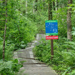
Have you already been on a short walk at the Edna Martin Wildlife Refuge along the edge of scenic Burr’s Pond? Maybe you’ve walked through the longer trails at Gamino Pond Conservation Area and connecting trails behind the Seekonk Public Library? Perhaps you’ve tried the 3 mile loop trails at Caratunk Wildlife Refuge owned by RI Audubon on Brown Avenue? And, you’ve already walked the beautiful flat and paved bike path along the northwest side of the Turner Reservoir accessed behind Kimberly Rock Fields up to to Slater Park? Are you ready to take a longer hike, with some historic interest?
The body of water split by Newman Avenue is the Turner Reservoir and has a trailhead on the west side that is part of the Turner Reservoir Loop Trail. This trail follows the shore with a post and rail fence along the property of the Bridgham Farm subdivision where there is a short trail to the right that will lead you into a cul-de-sac of the subdivision where you will see a very large oak tree, said to be over 400 year old known as the Newman Oak. Another site is just over the rooftops where you can catch a glimpse of the old windmill that was part of old Bridgham Farm. Following this trail by the oak tree leads into the Bridgham Farm Conservation Area and a large open field which was conserved during the 1990’s.
The trail continues back out to the reservoir where it follows the earthen embankment towards the Turner Dam built in the 1930’s to create the Turner Reservoir as a drinking supply for East Providence and was used as the primary water supply until the late 1960’s. The trail continues to the south and leads to a parking area along Route 114A. From here you can cross the street and walk up Hunts Mills Road to Hunts Mills Falls or cut back across the Ten Mile River Bridge into Seekonk and enter the boardwalk section of the trail on the eastern side of the Turner Reservoir Loop Trail.
Up towards Hunts Mill is the lovely Georgian style John Hunt House built in the second half of the 1700’s and the current home of the EP Historical Society. To the right of the house is a gazebo with a red trail marker designating the beginning of the three quarter mile Hunts Mills Trail. Along this stretch there are two rock outcrops by the river known as Sunset Rock and Otter Rock. When the river is low you might see turn of the century inscriptions on the rocks. Behind the Hunt House are informational boards describing the history of the property where once stood an amusement park, a carousel, and large stone pump house.
Back in the lot on the Seekonk side of 114A, the trail begins again on boardwalks that cross over the wetlands but soon come back to the earthen Turner Dam. Here, the view of the waterfall offers a sweeping view of the reservoir. The trail follows some blue blazes up towards Seekonk High School athletic fields and these wide groomed paths leads out to peninsulas that offers great views of the reservoir and eventually out to Arcade Avenue. You have short bit of road walking before turning left back to Newman Avenue and across the reservoir to where you began.
Enjoy the great outdoors and see you outside! Notice the variations of tree bark and shapes of trees seen so much easier in winter. Look for footprints in the snow. Listen to the birds and enjoy the fresh air. Just dress for the weather and the walking will keep you warm.
Would you be willing to write 1 or 2 sentences about what open land, hiking trails, and open space means to you and your family, especially during this past year? We hope your voice and the efforts of Seekonk Land Trust will be strengthened if we can include your experiences in our description of why land is so important to preserve. Feel free to mention specific places and or recommendations for future acquisition!
Please reply on our website https://www.seekonklandtrust.org, www.facebook.com/seekonkLCT, or email comments to kleddy44@gmail.com. You may see your comments in a future article.
Want to find a trail to take your dog? Need a spot that is ADA compliant? Searching for a safe canoe or kayak launch? Need maps to each trail head? You might need to get “Easy walks and paddles in the Ten Mile River Watershed” by Ten Mile River Watershed Council and Majorie Turner Hollman. It’s a users guide to 39 outdoor spaces in the towns that host the Ten Mile River (the river travels through Plainville, North Attleboro, Attleboro, Seekonk, Pawtucket, and East Providence before reaching a confluence at the Seekonk River at Omega Falls) and covers more than 120 trails in all.
For further information, please see https://www.seekonklandtrust.org or follow us on www.facebook.com/seekonkLCT


Comments
No comments on this item Please log in to comment by clicking here